የጥበቃ እና መዝናኛ መምሪያ የጥበቃ እና መዝናኛ መምሪያ
መጠበቅ. መከላከል. መደሰት.
የDCR ዓርማ
ተንቀሳቃሽ ምናሌ
የDCR ድር-ጣቢያን ይፈልጉ
Facebook Twitter YouTube Instagram LinkedIn
ስለ DCR
 
የስቴት ፓርኮች
 
ተፈጥሯዊ
ቅርስ
የአፈር እና ውሃ
ጥበቃ
መዝናኛ
እቅድ ማውጣት

ግድብ ደህንነት እና የጎርፍ ሜዳዎች
መሬት
ጥበቃ
  • የግድቡ ደህንነት እና የጎርፍ ሜዳዎች
  • ድጋፎች እና የገንዘብ ድጋፍ
    • የግድብ ደህንነት፣ የጎርፍ መከላከል እና ጥበቃ እርዳታ ፈንድ
    • የማህበረሰብ ጎርፍ ዝግጁነት ፈንድ ስጦታዎች እና ብድሮች
    • የማይበገር የቨርጂኒያ ተዘዋዋሪ ብድር ፈንድ
  • ግድብ ደህንነት
    • የግድቡ ደህንነት መመሪያ ሰነዶች
    • ግድብ ደህንነት እውቂያዎች
    • ግድብ ምደባ
    • የግድቡ ደህንነት ደንቦች (ፒዲኤፍ)
    • ግድብ ደህንነት ትምህርት
      • ግድቦች 101
      • የግድቡ ውድቀቶች
      • የግድቡ ደህንነት ግንዛቤ ቀን
      • ASSO ግድብ ባለቤት አካዳሚ
      • አውሎ ነፋስ ወቅት
      • የግድቡ ደህንነት አገልግሎት
    • የግድብ ደኅንነት ስልጠና
    • የግድብ ደህንነት፣ የጎርፍ መከላከል እና ጥበቃ እርዳታ ፈንድ
      • 2025 የስጦታ ሽልማቶች ዝርዝር (ፒዲኤፍ)
      • 2024 የስጦታ ሽልማቶች ዝርዝር (ፒዲኤፍ)
      • 2023 የስጦታ ሽልማቶች ዝርዝር (ፒዲኤፍ)
    • የግድቡ ደህንነት ቆጠራ ሥርዓት (DSIS)
    • ሊሆን የሚችል ከፍተኛ የዝናብ ጥናት እና የPMP ግምገማ መሣሪያ
    • ከፍተኛው የዝናብ ጥናት ዳራ
    • ጊዜያዊ ስርጭት ትንተና እና ስሌቶች የስራ ሉህ
    • ዕፅዋት, የአፈር መሸርሸር
    • የሮድ መቆጣጠሪያ
    • ቅጾች
  • የጎርፍ ሜዳዎች
    • Va. የጎርፍ ሜዳ አስተዳደር ፕሮግራም
    • የጎርፍ ሜዳ ህጎች እና ድንጋጌዎች
    • የVirginia የጎርፍ አደጋ መረጃ ሥርዓት
    • የጎርፍ ሜዳዎች ተፈጥሯዊ ተግባራት
    • የማህበረሰብ ደረጃ አሰጣጥ ስርዓት
    • የጎርፍ ሜዳ አስተዳደር መርጃዎች
    • በቨርጂኒያ የጎርፍ ግንዛቤ
      • የጎርፍ ግንዛቤ ሳምንት
      • የማዳረስ መርጃዎች
    • የጎርፍ ሜዳ እውቂያዎች
    • የጎርፍ መቋቋም አቅም የገንዘብ ድጋፍ
      • የማህበረሰብ ጎርፍ ዝግጁነት ፈንድ ስጦታዎች እና ብድሮች
        • CFPF ግራንት ሽልማቶች ዝርዝር
      • የማይበገር የቨርጂኒያ ተዘዋዋሪ ብድር ፈንድ
  • የጎርፍ መቋቋም እቅድ
    • የቨርጂኒያ የጎርፍ መከላከያ ማስተር ፕላን
      • ተሳተፍ
    • የቨርጂኒያ የባህር ዳርቻ የመቋቋም ማስተር ፕላን።
      • የባህር ዳርቻ የመቋቋም ማስተር ፕላኒንግ ማዕቀፍ
      • የባህር ዳርቻ የመቋቋም ማስተር ፕላን፣ ደረጃ 1
      • የባህር ዳርቻ የመቋቋም ማስተር ፕላን፣ ደረጃ 2
      • የባህር ዳርቻ የመቋቋም ችሎታ ድር አሳሽ
      • የድር አሳሽ የተጠቃሚ ፖርታል
    • ተሳትፎ እና ተሳትፎ
    • የቀን መቁጠሪያ, ስልጠና እና ዝግጅቶች
    • የጎርፍ መቋቋም አማካሪ ኮሚቴ
    • ዓመታዊ የጎርፍ ዝግጁነት ማስተባበሪያ ስብሰባ
    • የውሂብ ፖርታልን ክፈት
    • ምንጮች እና ሪፖርቶች
  • የቀን መቁጠሪያ, ስልጠና እና ዝግጅቶች
  • የጂአይኤስ ውሂብ መገናኛን ይክፈቱ
  • የጎርፍ ታሪክዎን ያካፍሉ።
መነሻ » የግድብ ደህንነት እና የጎርፍ ሜዳዎች » የጎርፍ መቋቋም አቅም እቅድ ግብዓቶች እና ሪፖርቶች

Flood Resilience Planning Resources


Flood Hazard Data

Understanding flood risk requires knowing which areas of your community are exposed to flooding today, and which areas are expected to be exposed in the coming decades. Due to changing patterns of precipitation, sea level rise, and development, historic flooding trends are no longer a useful predictor of future risk.

Nationwide, we lack consistent, locally specific data that forecasts flooding based on multiple risk sources. The Commonwealth is closing these data gaps and providing data tools to support flood resilience planning efforts in Virginia.

DCR flood data

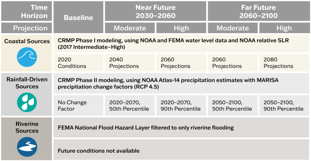
DCR provides two non-regulatory flood hazard datasets that can be used together with regulatory data to support more informed flood resilience planning: a coastal Virginia flood hazard dataset (developed for the Coastal Resilience Master Plan) and a statewide Fathom flood hazard dataset (procured for the Virginia Flood Protection Master Plan). The table below explores and compares these two resources.


Coastal Virginia Flood Hazard Data

Fathom Flood Hazard Data

Geographic Area

Coastal: localities within any of the eight easternmost Planning District Commissions in Virginia.

Statewide: The entire Commonwealth of Virginia.

Flood Hazards

Coastal, riverine, and rainfall-driven flooding

Coastal, riverine, and rainfall-driven flooding

Recurrence Intervals

Seven recurrence intervals: 1 in 2-, 5-, 10-, 25-, 50-, 100-, and 500-year.

Three tidal conditions (MLW, MHW, 1.5xMTR) are also available for coastal flood data.

Five recurrence intervals*: 1 in 10-, 25-, 50-, 100- and 500-year.

Associated DCR Plan

Coastal Resilience Master Plan (CRMP)

Virginia Flood Protection Master Plan (VFPMP)

Planning Scenarios

Five planning scenarios: baseline (2020), plus “moderate” and “high” scenario options for the near future (2030-2060) and far future (2060-2100) time horizons.

Five planning scenarios: baseline (2020), plus two “moderate” and “higher” scenario options for the 2060- and 2100-time horizons.

Basis for Future Conditions

Varies by flood source and planning scenario. See reference figure for more information.

Shared Socioeconomic Pathway 2-4.5 (SSP2-4.5). “Moderate” scenario based on median (50th percentile) values and “higher” scenario based on 83rd percentile values.

 Resolution

10-foot

10-meter (~33-foot)  

Source

DCR with underlying data from the United States Army Corps of Engineers, the National Oceanic and Atmospheric Administration, and the Federal Emergency Management Agency.

Fathom

Access

View and download data and methodology documentation via DCR’s Flood Resilience Open Data Portal.

View the 1 in 100- and 500-year data for baseline conditions via DCR’s Flood Resilience Open Data Portal.

Access to all other products is provided to VA public institutions.*

ተጨማሪ መረጃ

Learn more via the one-pager.

Learn more via the one-pager.

*Virginia government entities and state-recognized Tribal governments may sub-license all Fathom data from DCR for a 12-month renewable license term. To inquire about a sub-license agreement, including data use limitations, please contact us at flood.resilience@dcr.virginia.gov.

Other flood data

Additional data to visualize and understand flood hazards is available through state and federal platforms. Below is a snapshot of these data resources which can be accessed through the links provided.

  • FEMA Flood Hazard Data via DCR’s የVirginia የጎርፍ አደጋ መረጃ ሥርዓት (VFRIS) – VFRIS compiles and displays flood hazard data from the Federal Emergency Management Agency (FEMA) including Special Flood Hazard Areas. It also provides access to links to download FEMA Flood Insurance Studies, FEMA HEC-RAS Models. These maps also display non-regulatory flood hazard data including data from  and data do not incorporate future-looking projections based on changing precipitation patterns, new development or compound flood risk from tidal flooding events.

  • National Hurricane Center’s Storm Surge Risk Maps – includes data viewers and data downloads based on modeling which forecasts the extent and depth of storm surge resulting from hurricanes (category 1-5) for the Virginia coast. 

  • NOAA 2022 Sea Level Rise Technical Report – provides nationwide forecasts for sea level rise through 2150. The report provides more recent forecasts than were included in DCR’s coastal resilience web explorer and Phase I of the Coastal Resilience Master Plan. NOAA’s Sea Level Rise Viewer allows users to map and download the data.

  • NOAA Mid-Atlantic RISA Projected IDF Curve Data Tool – county-level tool for forecasting changes in precipitation depths from historic ATLAS-14 modeling to two future conditions (2020-2070 and 2050-2100) under two emissions scenarios (RCP 4.5 and RCP 8.5). The model forecasts precipitation change across six average recurrence intervals (2-year to 100-year) and 14 durations (5 minute to 7 day).

Tools for Planning

There are many tools to aid organizations in crafting a flood resilience plan. Below is an abbreviated list of useful planning tools. Additional tools can be found on the information gateways linked below.

Tools specific to Virginia

The following tools were developed with Virginia-specific needs in mind. While some are focused on exploring flood resilience specifically, others support resilience planning more broadly.

  • CFPF Resilience Plans - a DCR-approved Resilience Plan is required for localities submitting applications in the "project" category of the Community Flood Preparedness Fund. The requirements for an approved resilience plan can be found in Appendix F of the CFPF Grant Round 6 draft manual.
  • ADAPT VA – an information gateway on climate change adaptation for individuals, local programs, and agencies in Virginia. The website provides a variety of resources such as short and long-term sea level curves and maps, flood mapping and decision-support tools, legal and policy resources, and stories that explain adaptation through maps and pictures.
  • Proactive Planning for Resilience: Protocols for Community-Led Climate Adaptation Planning in Virginia – a Virginia-specific guide for climate adaptation planning for decision-makers across the Commonwealth. The website outlines steps for developing a plan, with detailed case studies, definitions, tools, legal considerations and best practices.
  • The RAFT and PREP Tool – The Resilience Adaptation Feasibility Tool (RAFT) Team is a Virginia state university partnership which brings capacity building and technical assistance to local governments over a period of 18 months to help build their resilience. Their team’s PREP Tool provides access to the RAFT’s methods and approach for assessing local government capacity for resilience and identifying and prioritizing projects to implement.

Federal Tools

Federal agencies have developed tools to assist organizations to plan and implement successful flood resilience strategies. The following resources may help you to craft your resilience plan.

  • US Climate Resilience Toolkit – a national portal that includes a variety of tools for building resilience to flooding impacts, including the Steps to Resilience Framework, which outlines a straightforward process for creating a resilience plan alongside resources to use to get there.
  • USACE’s International Guidelines on Natural and Nature-Based Features for Flood Risk Management – consolidates best practices for constructing natural and nature-based features for flood risk management into a guidance document for decision-makers and practitioners to use when considering these practices in flood resilience plan development.
  • US DOI Nature Based Solutions Roadmap – outlines information on nature-based solutions, including specific strategies, considerations for implementation, co-benefits, examples, and resources.

የመረጃ መግቢያ መንገዶች

These portals and databases contain a variety of resources – such as data, planning tools and funding information – that may be useful to your organization as you develop your resilience plan:

  • የFEMA መልሶ ማግኛ እና የመቋቋም ሀብት ቤተ-መጽሐፍት።
  • Association of State Floodplain Managers’ Library
  • ብሄራዊ የዱር አራዊት ፋውንዴሽን፣ በተፈጥሮ ላይ የተመሰረተ የመፍትሄ ሃሳቦች የገንዘብ ድጋፍ ዳታቤዝ

ለማቀድ እና ለመተግበር የገንዘብ ድጋፍ

Organizations developing flood resilience plans should consider approaches which align both with DCR’s flood resilience plan guidance, as well as with federal resources and funding opportunities. Resources to help you understand how to align your approach to resilience planning with available funding resources include:

DCR Flood Resilience Funding Resources

DCR administers the Community Flood Preparedness Fund (CFPF) and the Resilient Virginia Revolving Fund (RVRF).  For more information on these funds visit the DCR Floodplain Management, Flood Resilience Funding website.
Beyond the DCR administered resilience funds, the Coastal Resilience Web Explorer Funding Opportunities tab provides an inventory of funding sources that may be available to finance the development and/or implementation of your plan. While it is catered to the coastal region, non-coastal activities may be eligible for some listed opportunities.
The DCR Flood Resilience Funding Geographic Focal Area Viewer identifies geographic areas that are designated as either required or preferred for resilience funding, including Low-Income Geographic Areas for the DCR Community Flood Preparedness Fund.

Other Funding Resources

  • የፌደራል የድንገተኛ አደጋ አስተዳደር ኤጀንሲ (ኤፍኤማ) እና የቨርጂኒያ የድንገተኛ አደጋ አስተዳደር መምሪያ (VDEM)
    • የFEMA የአደጋ ቅነሳ እገዛ መመሪያ
    • VDEM የእርዳታ ፕሮግራም መረጃ
    • የ COVA አደጋ ቅነሳ እቅድ
  • የዩናይትድ ስቴትስ ጦር ሰራዊት መሐንዲሶች (USACE)
    • Flood Risk Management Mission to learn more about the Corps’ available assistance programs.
    • Division and District Information to determine the appropriate point of contact to learn more.  USACE is broken into watershed-based divisions and districts.
  • Others
    • American Flood Coalition Flood Funding Finder
    • U.S. Climate Resilience Toolkit Funding Resources

ሪፖርቶች

በቨርጂኒያ ካለው የጎርፍ መቋቋም እቅድ ጋር ተዛማጅነት ያላቸው ታሪካዊ ሪፖርቶች ከታች ባለው ተቆልቋይ ሜኑ በኩል ተቀምጠዋል።

2025 በቨርጂኒያ ኮመንዌልዝ የሁኔታ ዝማኔ የመቋቋም ችሎታ

በ 2024 ጠቅላላ ጉባኤው ክፍለ ጊዜ፣ የሃውስ ቢል 1458 የጎርፍ መቋቋም ሁኔታን በVirginia ኮድ (§ 2.2-220.5) አሻሽሏል በጎርፍ መቋቋምን ጨምሮ በኮመንዌልዝ ውስጥ አጠቃላይ የመቋቋም ሁኔታን ለማካተት። በጁላይ 2025 እና ከዚያ በኋላ በየሁለት አመቱ የተለቀቀው ሪፖርቱ ባለፉት ሁለት አመታት ውስጥ በCommonwealth የተቀበሉትን እና የተከፋፈሉትን የአደጋ መከላከል የገንዘብ ድጋፍን በተመለከተ በዋና የድጋሚ መቋቋሚያ ኦፊሰር እና የክልል ኤጀንሲዎች የተከናወኑ ተግባራትን ሁኔታ ያካትታል።

በቨርጂኒያ ኮመንዌልዝ የሁኔታ ማሻሻያ ውስጥ2025 የመቋቋም ችሎታንያንብቡ

2023 Resilience Coordination Working Group Report

በ 2024 ጠቅላላ ጉባኤው ክፍለ ጊዜ፣ የሃውስ ቢል 1458 የጎርፍ መቋቋም ሁኔታን በVirginia ኮድ (§ 2.2-220.5) አሻሽሏል በጎርፍ መቋቋምን ጨምሮ በኮመንዌልዝ ውስጥ አጠቃላይ የመቋቋም ሁኔታን ለማካተት። በጁላይ 2025 እና ከዚያ በኋላ በየሁለት አመቱ የተለቀቀው ሪፖርቱ ባለፉት ሁለት አመታት ውስጥ በCommonwealth የተቀበሉትን እና የተከፋፈሉትን የአደጋ መከላከል የገንዘብ ድጋፍን በተመለከተ በዋና የድጋሚ መቋቋሚያ ኦፊሰር እና የክልል ኤጀንሲዎች የተከናወኑ ተግባራትን ሁኔታ ያካትታል።

  • ሙሉውን የመቋቋም ማስተባበሪያ የስራ ቡድን የመጨረሻ ሪፖርት እና ምክሮችንያውርዱ
  • የአቋም መግለጫውን የ Resilience Coordination Working Group የመጨረሻ ምክሮችንያውርዱ

የቨርጂኒያ ኮመንዌልዝ ዩኒቨርስቲ (VCU) የህዝብ ፖሊሲ ማእከል (ሲፒፒ) ከኮመንዌልዝ ለተደጋጋሚ የጎርፍ አደጋ መቋቋም (CCRFR) በተገኘ የገንዘብ ድጋፍ RCWGን አመቻችቷል።

2023 የጎርፍ መቋቋም ሪፖርት ሁኔታ

በ 2023 ውስጥ፣ የኮመንዌልዝ ዋና የመቋቋም ኦፊሰር በቨርጂኒያ ውስጥ ስላለው የጎርፍ መቋቋም ሁኔታ በቨርጂኒያ ህግ (§ 2.2-220.5) መሰረት ለገዥው እና ለጠቅላላ ጉባኤው የሁለት አመት ሪፖርት አሳትሟል።

የ 2023 የጎርፍ መቋቋም ሁኔታን ያንብቡ።

መነሻ » የግድብ ደህንነት እና የጎርፍ ሜዳ አስተዳደር » የጎርፍ መቋቋም ዕቅድ
የVirginia ጥበቃና መዝናኛ መምሪያ
600 East Main Street፣ 24ኛ ፎቅ | Richmond፣ VA 23219-2094 | 804-786-6124
Please send website comments to web@dcr.virginia.gov
Address general inquiries to pcmo@dcr.virginia.gov
Copyright © 2026, Virginia IT Agency. All Rights Reserved
Last Modified: Wednesday, 21 January 2026, 10:38:47 AM
eVA ግልጽነት ሪፖርቶች የVirginia ጥበቃ እና መዝናኛ መምሪያ ወጪዎችን ለመመልከት።
ያነጋግሩን | የሚዲያ ማዕከል | የግላዊነት ፖሊሲ | የADA ማስታወቂያ | FOIA | የሥራ ቦታዎች | የሥነ ምግባር ሕግ (PDF)
DCR ድርጅታዊ ሠንጠረዥ (PDF) | ስልታዊ ዕቅድ (PDF) | የስራ አስፈፃሚ ግስጋሴ ሪፖርት (PDF) | የህዝብ ደህንነት እና የሕግ ማስከበር